It was just another day on the Baglung-Muktinath Road. The September rain had been a little out of control, but people’s lives continued. A vehicle filled with pilgrims were heading to Muktinath, and as they were passing the Lower Mustang, along the Kali Gandaki valley, they witnessed something they were not ready for. The busriders witnessed a chunk of mountain fall from atop them and slide into the Kali Gandaki gorge 3 km below, taking a portion of the land about 50 metres ahead of them.
This was on September 26, 2026 (Saturday). The hillside came down at Lete and blocked the Kali Gandaki. It was filmed by pilgrims on their way to Muktinath; The video went round the world. The river cut through the edge of the blockage quickly, so there was no flood wave downstream. As of September 29, the Nepal government disaster register (BIPAD) had no mass-fatality record for it. From Saturday night, power and internet were cut. The 33 kV line from Dimukha in Parbat lost its poles to floods and erosion. San Prasad Thakali of the Nilgiri Consumers Cooperative in Jomsom explained the line; Hum Bhujel, Nepal Telecom’s Jomsom chief, said phone and 4G were running on radio links in places, with crews in Baisari (Myagdi) and Lete. On the same day as the Lete slide, an avalanche buried Himlung Himal base camp in Manang (Gandaki Province): 16 people, mostly expedition kitchen staff plus two
guides. Four bodies recovered (some outlets say two); 12 still missing. 11 people whose tents were away from the slide path survived. The Nepal National Mountain Guides Association paused the search on 29 September: “With only eight people on scene, our manpower wasn’t enough to continue the search.” The same base camp was hit in 2014.
Lete is in Mustang, the driest district in Nepal, which has recorded four landslide deaths since 2015 on the government’s own disaster register. I was looking for why the dry valley had stayed quiet.
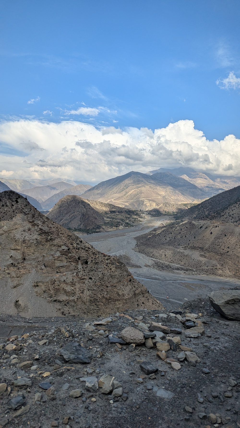 The Kali Gandaki valley in Upper Mustang, April 2025. Photo © Dona Dey
The mountains used to fall south
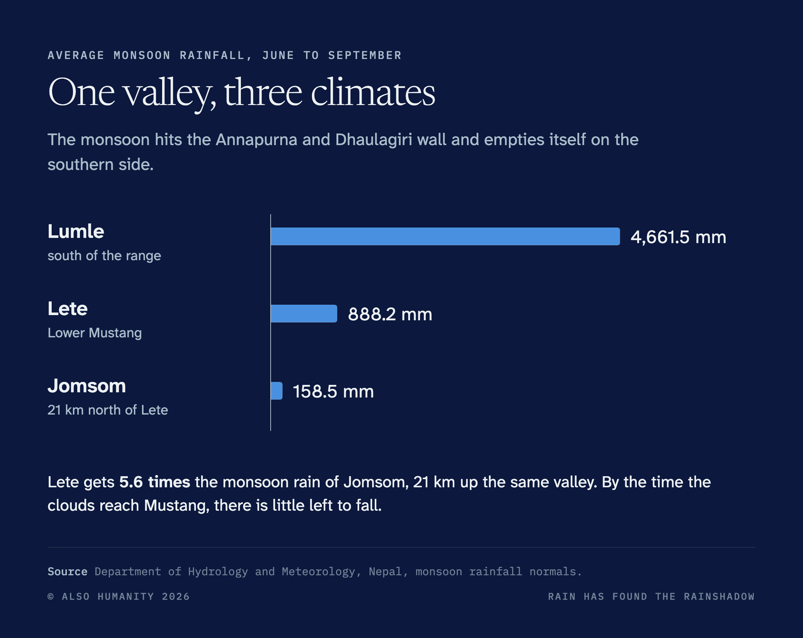
The answer, for most of recorded history, was simple. Mustang sits behind the Annapurna and Dhaulagiri ranges, in their rainshadow. The monsoon comes up from the Bay of Bengal, hits that wall and empties itself on the southern side. In an average monsoon, Lumle, south of the range, gets 4,661.5 mm of rain, while Lete gets 888.2 mm. Jomsom, 21 km further up the same valley, gets 158.5 mm. By the time the clouds reach Mustang, there is little left to fall.
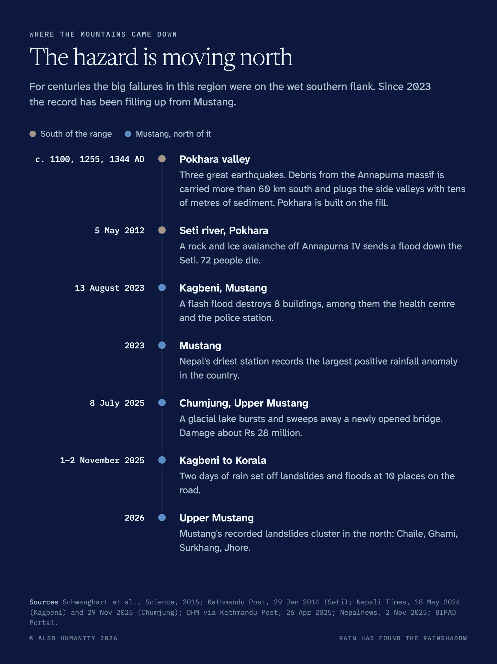
So the mountains that came down in the history were in the south. The ground Pokhara stands on is one of them. Around 1100, 1255 and 1344 AD, three great earthquakes struck this part of Nepal, and debris from the Annapurna massif was carried more than 60 km south. It plugged the side valleys with tens of metres of sediment. Over the last thousand years, scientists estimate, about four cubic kilometres of the mountain moved downhill this way. Pokhara is built on that fill. In May 2012 the Seti did it again on a smaller scale: a rock and ice avalanche off Annapurna IV sent a flood down to Pokhara, and 72 people died.
The Nepal government’s disaster register tells the same story. Since 2015, Kaski has recorded 78 landslide deaths, Baglung 65, Myagdi 62 and Parbat 32. Mustang has recorded four.
The rain is moving north
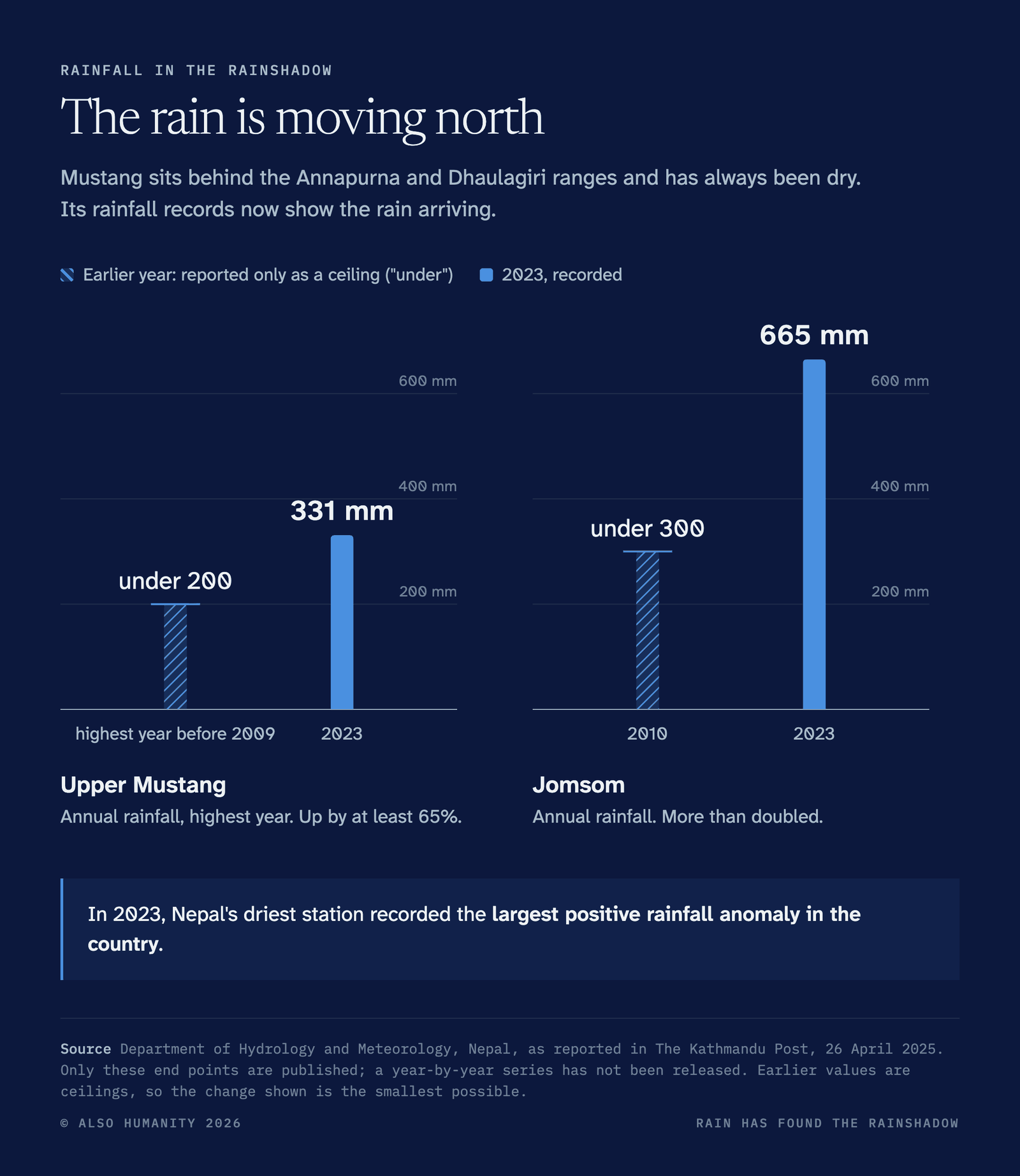
That is changing. Before 2009, the highest annual rainfall recorded in Upper Mustang was under 200 mm. By 2023 it was 331 mm. At Jomsom, the district headquarters, the yearly total went from under 300 mm in 2010 to 665 mm in 2023. That year, according to the Department of Hydrology and Meteorology, Nepal’s driest station recorded the largest positive rainfall anomaly in the country.
The landslides have followed the rain. This year, Mustang’s recorded incidents cluster in the north, around Chaile, Ghami, Surkhang and Jhore, in Upper Mustang rather than the southern gorge where earlier years’ slides were. In August 2023 a flash flood destroyed eight buildings in Kagbeni, among them the health centre and the police station. In July 2025 a glacial lake burst at Chumjung and took a new bridge with it. In November 2025, two days of rain set off landslides and floods at 10 places on the road from Kagbeni to Korala.
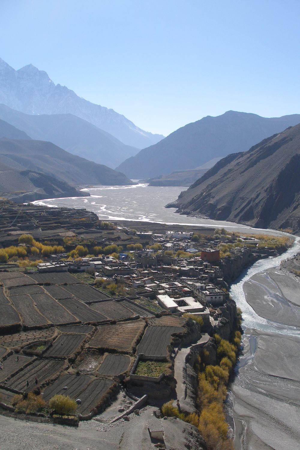 Kagbeni and the Kali Gandaki. Vyacheslav Argenberg (CC BY 4.0), via Wikimedia Commons
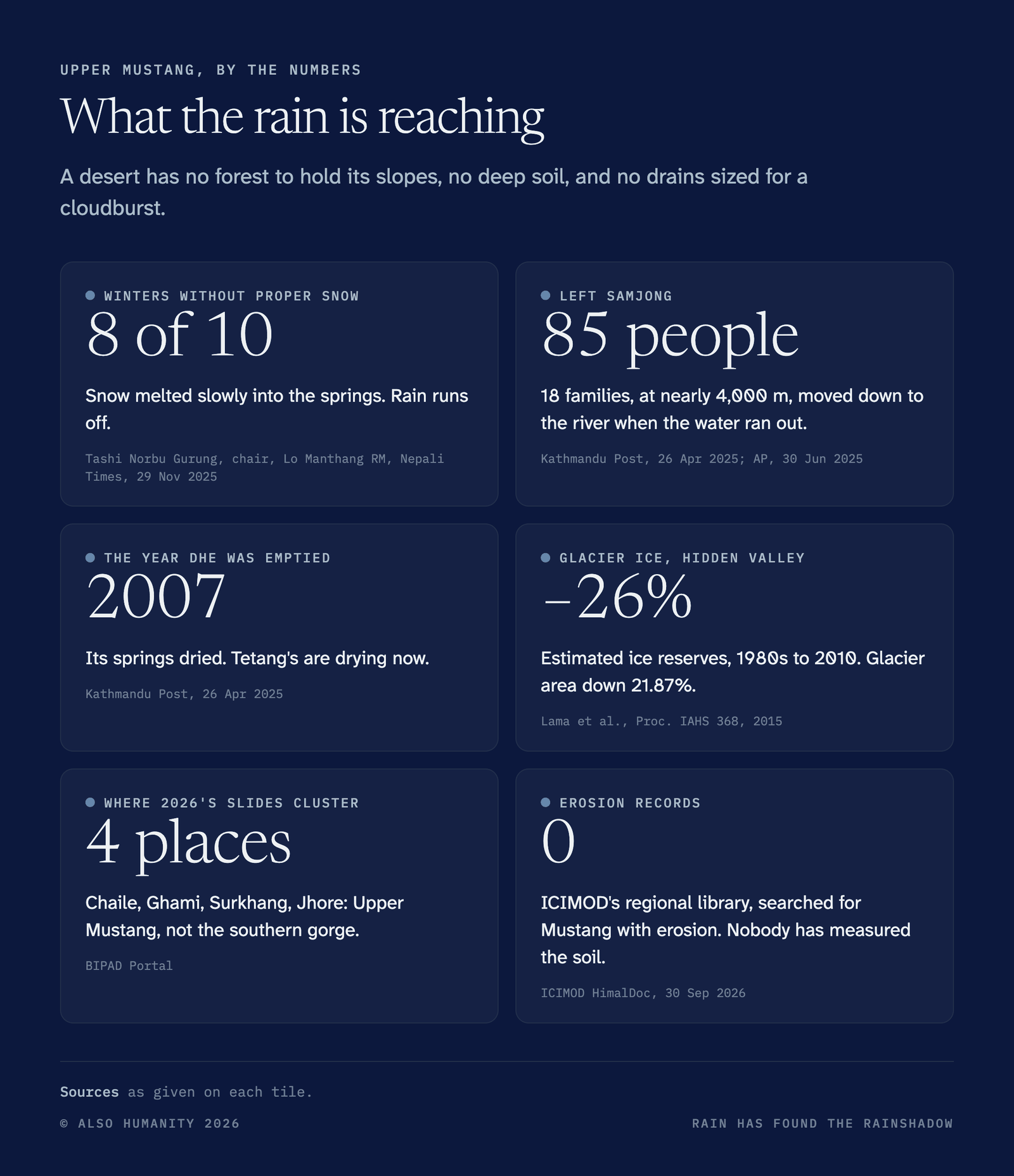
Rain is also arriving where snow used to. Winter snow has failed in eight of the past ten years, says Tashi Norbu Gurung, chair of Lo Manthang Rural Municipality. Snow sat on the ground and melted slowly into the springs. Rain runs off. “The geography of Mustang naturally lacks the capacity to store water,” Arun Bhakta Shrestha of ICIMOD told the Kathmandu Post. “Its entire ecosystem depends on regular snowfall.” The geographer Monique Fort warned in 2014 that as snow cover and the seasons shifted, the shale slopes of the upper Kali Gandaki would see more earthflows, and that heavy snow followed by fast melt could bring flash floods.
The people of Upper Mustang already live with both ends of it. Samjong, at nearly 4,000 m, ran out of water, and its 18 families, 85 people, moved down to a new settlement by the river. Dhe was emptied in 2007 after its springs dried. Tetang’s springs are drying now. “We don’t have water when we need it,” Nyima Wangmo Gurung, who runs a homestay in Nyamdok, told the Nepali Times. “And there is too much when we don’t need it.”
The houses were not built for it either. In Thini, a village above Jomsom, most homes are made of mud and stone, with flat mud roofs, and some are 200 years old. Houses like these were made for a dry place and light snow. Now the roofs leak and the walls are wearing away at the base. “Water leakage from the roof is becoming a headache now,” Sudip Thakali, a civil engineer in Thini, told Mongabay. He has plastered his walls with cement and plans to replace his mud roof with concrete. Sabi Thakali, a farmer who runs a small hotel in the village, built a cement house in 2019 to keep his family safe from the rain. It cost about Rs 7 million, twice the price of a mud house, and he says it is too cold in winter. “The flat roofs cannot cope with hard and extensive rainfall,” says the American anthropologist Mark Aldenderfer, who has worked in Mustang for years. In Lo Manthang, the mud stupas and monuments are eroding. The roads were not built for rain either: two days of it in November 2025 broke the Kagbeni–Korala road in 10 places. Very little in Mustang was made to stand up to rain, but things are changing.
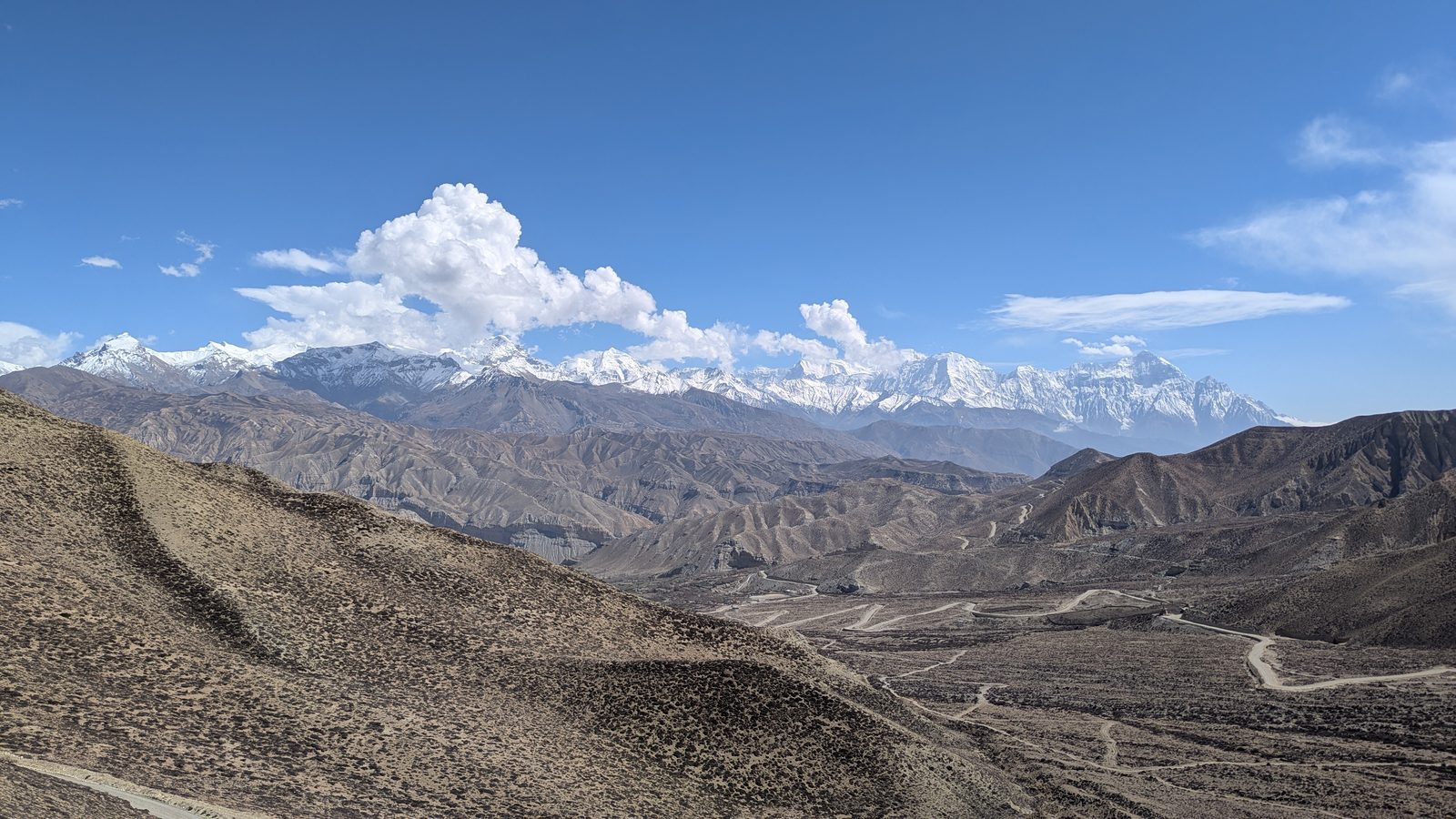 Dry hills and new roads in Upper Mustang, below the snow-covered Himalaya, April 2025. Photo © Dona Dey
A desert is not built for rain. Upper Mustang has no forest to hold its slopes, no deep soil, and no drains sized for a cloudburst. Nobody has measured what the rain is doing to its ground. Search ICIMOD’s regional research library for Mustang and erosion, and it returns no records.
The mountain at Lete fell in the wettest corner of Mustang. The rain is now reaching the driest.
Sources
- BIPAD Portal, Government of Nepal, district landslide incident and fatality records, 2015 to 30 September 2026.
- Department of Hydrology and Meteorology, monsoon rainfall normals for Lumle, Lete and Jomsom; Upper Mustang and Jomsom annual rainfall as reported in The Kathmandu Post, 26 April 2025.
- Schwanghart, W. et al., “Repeated catastrophic valley infill following medieval earthquakes in the Nepal Himalaya”, Science, 2016 (online December 2015); GFZ/University of Potsdam press release on sediment volume.
- On the 2012 Seti flood: Kathmandu Post, 29 January 2014; Nepali Times.
- Kagbeni flood, 13 August 2023: Wen Stephenson, Nepali Times, 18 May 2024. Chumjung GLOF, 8 July 2025, and the snowfall and Nyamdok quotes: Nepali Times, 29 November 2025. Kagbeni–Korala road, 1–2 November 2025: Nepalnews, 2 November 2025.
- Samjong and Dhe: The Kathmandu Post, 26 April 2025; AP, 30 June 2025. Arun Bhakta Shrestha: The Kathmandu Post, 26 April 2025.
- Thini houses and quotes from Sudip Thakali, Sabi Thakali and Mark Aldenderfer: Tanka Dhakal, “Changing weather patterns threaten time-tested houses in Nepal village”, Mongabay, 29 November 2025. Lo Manthang’s mud monuments: Diya Rijal, Nepali Times, 29 November 2025.
- Fort, M., “Natural hazards versus climate change and their potential impacts in the dry, northern Himalayas: focus on the upper Kali Gandaki (Mustang District, Nepal)”, Environmental Earth Sciences 73(2):801–814, 2014.
- ICIMOD HimalDoc, queried 30 September 2026: Mustang with erosion, zero records.
- Lete landslide: Petley, D., Eos landslide blog, 29 September 2026. Blackout: Onlinekhabar, 28 September 2026. Himlung: The Himalayan Times; Explorersweb, September–October 2026.